By Craig Romano
Snow-clad and draped in glacial ice, it seems unlikely that wildfire would pose a threat to Mount Rainier. However, ringing the base of the 14,410-foot volcano is a nearly unbroken canopy of towering firs, hemlocks, and cedars within the 235,000 acre national park. And surrounding the park are millions of acres of additional timberland managed within national and state forests and private tree farms. When the nascent United States Forest Service decided that it was a good idea to start building fire lookouts to watch over this treasure trove of timber, they looked toward Rainier’s lofty slopes as the perfect spots to site them.
In 1916, the Forest Service constructed a stone shelter for fire watching at 9,584 feet on Mount Rainier’s Anvil Rock, just below Camp Muir. The rock hovel was replaced 12 years later by a cupola cabin. And while this location did indeed provide excellent fire finding with its sweeping horizon-spanning views, all too often it was shrouded in clouds prohibiting any viewing at all.
That was the issue, too, with the park’s second fire lookout, situated on a 7,176-foot point on the Colonnade on Rainier’s northwest shoulder. Built in 1930, it was soon taken out of use, replaced by a new tower at lower Sunset Park. But Anvil Rock remained staffed until 1942, not so much as to report fires but to record weather data. Soon after the first tower was constructed on Mount Rainier, the park service and the forest service realized what many hikers know today–that some of the best and more reliable alpine views aren’t on the mountain itself, but on the surrounding lower ridges and knobs immune to near-perpetual cloud cover.
By the 1930s, the park service and forest service began surveying more appropriate locations for fire lookouts. And with the nation in a Great Depression with millions of unemployed young men enrolled in Civilian Conservation Corps (CCC); officials had an army of labor at their disposal to construct new fire towers.
Up they went, mostly two-story cabins with wraparound balconies; simple in elegance and utilitarian in design. Within the national park, seven new fire towers were built: Shriner Peak in 1932, Tolmie Peak in 1933, Sunset Park in 1933, Gobblers Knob in 1933, Mount Fremont in 1934, Crystal Mountain and another lookout on a nearby knoll above Crystal Lake in 1934. And along the park’s periphery in the Snoqualmie National Forest (now Mount Baker-Snoqualmie), Wenatchee National Forest (now Okanogan-Wenatchee) and Columbia National Forest (now Gifford Pinchot), the CCC constructed scores of fire lookouts on ridges, knolls and summits. To the north, lookouts sprouted up on Clear West Peak, Suntop, Kelley Butte, and Bearhead Mountain, among others.
To the south, a precariously built lookout rose above sheer ledges on 5,685-foot High Rock. And a lookout was built on a 6,310-foot rounded knoll in the Tatoosh Range; where long before beat poet Jack Kerouac immortalized the Deception Peak lookout in the North Cascades, author Mary Hardy penned a well-received book, “Tatoosh.” in 1947 about her experiences as a fire watcher during World War II.
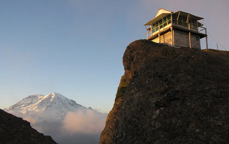
Along Mount Rainier National Park’s western boundary, a lookout tower was built in 1934 on 5,450-foot Glacier View peak. Thirty years later, the Washington Department of Natural Resources constructed a tower on 4,930-foot Puyallup Ridge. It still stands and is listed on the National Historic Lookout Register. However, it is rarely visited due to access issues over private land.
But the lookouts that still remain are accessible (mostly by trail) to the general public. Within the national park, four fire towers remain, one in each corner of the park. And while they share the same construction–two-story, wood-framed, wraparound windows and balcony–they each provide a unique view and perspective of the sprawling forests surrounding Mount Rainier, and of the mountain itself.
Here’s a thumbnail of each, including how to visit them:
Tolmie Peak
Sitting watch over the northwest corner of the park, Tolmie’s 5,939-foot summit commands impressive views from the mountain to the Sound. The trailhead is reached via the Mowich Lake Road, where you follow the Wonderland Trail north for 1.5 miles to Ipsut Pass. Then bear left for 1.7 miles through open forest and sub-alpine meadows skirting sparkling Eunice Lake before making the final ascent to the peak.
Mount Fremont
Perched on a ridge over 7,000 feet, it has the distinction of being Rainier’s highest remaining lookout. Situated in the drier northeast side of the park, the meadows here are punctuated with pumice and rock. The view of Rainier’s impressive Willis Wall and Emmons Glacier is breathtaking. Thanks to a lofty trailhead elevation of 6,400 feet at Sunrise, you needn’t work hard hiking the 2.7 miles.
Shriner Peak
The loneliest of Rainier’s lookouts, Shriner guards the quiet southeast corner of the park. The 4-mile hike to this 5,834-foot peak begins off of State Route 123. With over 3,400-feet of elevation gain, the trail is often deserted. Consequently, chances are good for viewing wildlife. Much of the peak’s lower slopes were engulfed by a wildfire before the lookout was constructed, creating open meadows and prime habitat. Bear, elk, deer, and grouse are abundant.
Gobbler’s Knob
At 5,485-feet, Gobbler’s Knob is the lowest of Rainier’s lookouts and the closest one to the volcano. It used to be the shortest to reach, too, just a 2.5-mile hike from Round Pass off of the West Side Road. But Tahoma Creek has continuously flooded the road, forcing its closure. To reach the trailhead now, you must first bike or walk an additional four miles.
Nearby remaining lookouts on national forest lands also invite exploring and make for excellent hiking destinations:
- Suntop is perched on a 5,271-foot open knoll just north of the park. Reached by Forest Road 7315 (off of FR 73 near The Dalles Campground on State Route 410), it is a popular family picnicking and sightseeing spot. Hikers and mountain bikes can access it by following a 7.5-mile trail from Buck Creek.
- High Rock, perhaps the most dramatic of the remaining lookouts, sits on a precipitous peak above sheer cliffs over 600 feet high along the appropriately named Sawtooth Ridge. The trailhead is reached by following Forest Road 8440 from Skate Creek Road.
- Kelly Butte was recently restored by volunteers. The 1.7-mile trail, too, has been rebuilt in places, making what was once a short and steep hike a little less steep. Chances are good of seeing mountain goats. Reach the trail via Forest Road 7030 off of Greenwater River Road.
These lookouts, like many of the surviving fire lookouts from coast to coast, are primarily no longer used for fighting forest fires. Succumbing to aircraft surveillance, these backcountry sentinels remain historic landmarks. But beyond their weathered clapboards, they ignite passion and awe in their admirers by offering some of the hottest views in the Northwest.
Source: Visit Rainier, a non-profit organization that promotes Mount Rainier tourism.